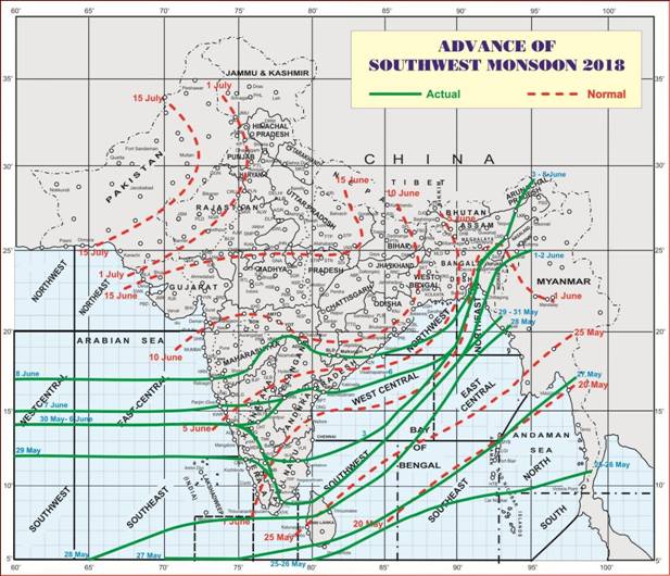
- Monsoon Advance:
Southwest Monsoon has further advanced into some more parts of Central Arabian Sea, remaining parts of Goa, Karnataka and Rayalaseema, some parts of south Konkan, south Madhya Maharashtra, Marathwada, Vidarbha, south Chhattisgarh and south Odisha, entire Telangana, most parts of Coastal Andhra Pradesh, remaining parts of West Central Bay of Bengal and most parts of North Bay of Bengal. The Northern Limit of Monsoon (NLM) passes through Lat. 17°N/ Long. 60°E, Lat. 17°N/ Long. 70°E, Ratnagiri. Solapur, Nanded, Adilabad, Bailadila, Malkangiri, Kalingapatnam, Lat. 21°N/ Long. 90°E, Agartala, Lumding, north Lakhimpur and Lat. 29°N/ Long. 95°E. (Figure 1)
Conditions are favorable for further advance of Southwest Monsoon into some more parts of Central Arabian Sea, Maharashtra (including Mumbai), Chhattisgarh & Odisha and remaining parts of Coastal Andhra Pradesh during next 24 hours.
Conditions are very likely to become favorable for further advance of Southwest Monsoon into most parts of Arabian Sea, remaining parts of Maharashtra, some parts of south Gujarat region, southern parts of Madhya Pradesh, some more parts of Chhattisgarh and Odisha, some parts of West Bengal & Sikkim, remaining parts of Northeastern States and Bay of Bengal during the subsequent 48 hours.
- Strengthening of Monsoon leading to enhanced rainfall activity along west coast:
Increased rainfall activity over coastal Karnataka, Goa and south Maharashtra is likely to continue till 10thJune. It is very likely to extend to north coastal Maharashtra, including Mumbai from tomorrow. Extremely heavy rainfall at isolated places in these regions is also very likely during this period. The rainfall activity over these regions is likely to reduce from 12th June.
Date-wise heavy rainfall warning for the next five days is given in the following table:
| Region | 08 June | 09 June | 10 June | 11 June | 12 June |
| Coastal Karnataka | Scattered heavy to very heavy with isolated extremely
heavy |
Isolated heavy to very heavy | Isolated heavy to very heavy | Isolated heavy | Isolated heavy to very heavy |
| Goa | Scattered heavy to very heavy with isolated
extremely heavy |
Scattered heavy to very heavy | Isolated heavy to very heavy | Isolated heavy to very heavy | Isolated heavy. |
| South Konkan | Scattered heavy to very heavy with isolated extremely
heavy |
Scattered heavy to very heavy with isolated extremely
heavy |
Scattered heavy to very heavy | Isolated heavy to very heavy | Isolated heavy. |
| North Konkan | Scattered heavy to very heavy | Scattered heavy to very heavy with isolated extremely
heavy |
Scattered heavy to very heavy | Isolated heavy to very heavy | Isolated heavy |
| South interior Maharashtra | Scattered heavy to very heavy with isolated
extremely heavy |
Scattered heavy to very heavy with isolated
extremely heavy |
Isolated heavy | Nil | Nil |
| North interior
Maharashtra |
Nil | Isolated heavy | Isolated heavy | Nil | Nil |
Wind warning:
In association with strong monsoon conditions over Arabian Sea, squally wind speed reaching 40-50 kmph gusting to 60 kmph likely along and off Konkan and Goa coasts during 8th to 12th June.
Sea condition:
Sea condition will be rough to very rough over east central Arabian Sea off Konkan and Goa coasts as well as over west central and adjoining southwest Arabian Sea off Somalia coast during 8th to 12th June.
Fishermen warning:
Fishermen are advised not to venture into over east central Arabian Sea off Konkan and Goa coasts as well as west central and adjoining southwest Arabian Sea off Somalia coast during 8th to 12th June.
- Formation of low pressure system:
A low pressure area is very likely to form over north Bay of Bengal during next 24 hours. It is very likely to intensify into a depression during the subsequent 48 hours and move towards Bangladesh coast.
Heavy rainfall warning:
Rainfall activity will increase over north Odisha, West Bengal & Sikkim, Assam and Meghalaya during 9-11th June with the occurrence of isolated heavy to very heavy rainfall
Wind warning:
Squally wind speed reaching 40-50 gusting to 60 kmph wind is very likely over north Bay of Bengal along and off West Bengal, Odisha and Bangladesh coasts during 9th to 10th June.
State of Sea:
Sea condition will be rough to very rough during this period over north Bay of Bengal along and off West Bengal, Odisha, Bangladesh, and Myanmar coasts.
Fishermen warning:
Fishermen are advised not to venture into North Bay of Bengal during 9th and 10th June.


